documented reconstructed the other possible route

In December 1847 a government surveyor walked the shore of a lake north of St. Paul. It was shaped like a ring, with an island in the middle, and he wrote its size inside: 357 acres of water and land. It had no name yet.2

Two years later a man named Abraham Lambert bought the island in the middle.

Lambert Lake

and the family it's named for

Vadnais Heights and Little Canada, Minnesota

Scroll

Prologue Sainte-Marie

The family tree begins with Eustache Lambert, born about 1617 or 1618, probably near Boulogne, in the north of France.9

He crossed in the early 1640s, probably in 1644. He never learned to write; he signed with a mark instead of his name.5, 9

No ship or route is recorded. The map follows the usual way of French ships then, by the Strait of Belle Isle and up the river past Gaspé and Tadoussac.

By 1646 he was paddling up the rivers to Sainte-Marie among the Hurons, the Jesuit mission near today's Midland, Ontario, where he served as an interpreter. In 1649, in the war that destroyed the Huron country, the mission was burned and abandoned.9

In 1653 he started over. He took a strip of riverfront at Pointe-Lévy, across the St. Lawrence from Quebec, and named the farm Sainte-Marie, after the mission of his youth.5, 9 He married Marie Laurence in 1656, and his farm became a meeting place for Huron and Algonquin traders passing Quebec. He died at Quebec in July 1673.

more

The grant was eight arpents of river frontage by forty deep, roughly a third of a mile by a mile and a half, and the only rent was a tenth of his eels. He was fishing there by 1651. The family tree gives his death as 6 June 1673; the Dictionary of Canadian Biography gives 6 July.

I. Lauzon

Six generations lived on the Lauzon shore, father to son, from Eustache to Abraham.

more

Eustache's eldest son, Gabriel, ran Sainte-Marie from the age of twenty and lived his whole life there, a man "of gentle and quiet ways." Next door farmed Jean Dumets, the ancestor of the Demers family.5 Gabriel's son Louis-Joseph, known as Monsieur de Sainte-Marie, was commanding the south-shore militia when Wolfe's army came up the river in 1759.5

From there the family tree traces the line down, father to son, to Joseph Lambert and Judith Magnan.17 Their son Abraham was born at Lauzon on 5 June 1792,6, 18 the sixth generation on that shore, and grew up to farm it.

Roy warns that more than one unrelated Lambert family lived in the seigneury, so the links from Eustache down to Abraham's father still want checking against the original parish registers. In 1759 the families of the shore spent five months hiding in the woods while British guns on the Lévis heights fired across at Quebec; Louis-Joseph died the next January, still in command. In 1776 the King's commissioners struck off a Pointe-Lévy militia captain named Joseph Lambert for serving the American "Rebels"; which Lambert he was is not known, and he is probably where the family tree's "Patriot" comes from.5, 17

On 22 January 1822, at Saint-Nicolas, Abraham married Rose Angèle Demers, the daughter of Michel Demers and Rosalie Foucher. He was twenty-nine. He married into a big family: in the years after, he stood as a witness at her brothers' and sisters' weddings.6

Their first child, a girl, was born the next May and baptized Rosalie, after her grandmother. Her godparents were her two grandparents, Judith Magnan and Michel Demers. She is very probably the Rose Angélique of the rest of this story.

more

The children, as the family tree and the gravestones list them: Rose Angélique (1823), Louis Abraham Thomas (1825), Félicité (1833), Pierre (1833), Le Sanges (1834), Esther (1835), Elizabeth (1837), Joseph Modeste (1838), and Marie (1849, at Little Canada). The county history counts six children on the journey west.10, 17, 18

In November 1828 the bishop planted the cross for the church of a new parish, Saint-Jean-Chrysostome, in the village of Beaulieu, on la terre d'Abraham Lambert, the land of Abraham Lambert. It was very probably this Abraham; Esther was born in that parish. The neighbours argued the spot was too far from the middle, and the next summer the site moved.5

Then came hard years. Cholera reached Canada in June 1832 and killed twenty-five people at Pointe-Lévy and thirteen at Saint-Nicolas by July, the Lamberts' two parishes. The harvests failed three years running. In 1834 a member told the Assembly he had seen fields at Saint-Jean-Chrysostome "entirely destroyed by hail," and that even the potatoes had failed.5 Abraham and Rose Angèle had small children then: Félicité was born in 1833, Esther in 1835.

Rose Angèle's younger brother, Modeste Demers, had become a priest. In 1838 he set out across the continent with Father François-Norbert Blanchet, to serve the French-Canadian farmers settled in the Oregon Country.7, 6 That January, Abraham and Rose Angèle had named their newborn son Joseph Modeste, very likely for his uncle.

The missionaries' letters came home in print, in the yearly report of Quebec's mission society. The report of January 1840 described the country in words a farmer would remember:8

très-propre à recevoir des colons ; le climat est doux, le sol fertile

"well suited to settlers; the climate is mild, the soil fertile." Rapport sur les missions du diocèse de Québec, January 1840

In 1841 Abraham was forty-nine, on the shore where his people had lived for almost two hundred years. The record doesn't say why he left. The hungry years were fresh, the old seigneury was full, and his wife's brother was a priest among Canadien farmers in a mild, fertile country. Likely all of it weighed on him. He started anyway.

II. The Journey West

Abram Lambert with his family of wife and three sons and three daughters left Lower Canada, in 1841…

Neill, History of Ramsey County, 1881

They went up the St. Lawrence by steamer, changing to a stage around each rapid above Montreal, then crossed Lake Ontario and took a little railroad past Niagara to Buffalo.24 There they boarded one of the big lake steamers that lived on emigrants and their farm tools: about a week on the water, past Detroit and around by Mackinac to Chicago.25

The stops and years are recorded; the roads and days are reconstructed. Solid lines are documented, dashed lines the likeliest way.10, 23

Chicago was a young town, and its canal to the Illinois River was not yet finished. A stage carried them across the prairie to Peru, and a steamboat down the Illinois to the Mississippi.24 At St. Louis, an old French river town, they stopped and, in the county history's words, "spent the winter."10

In the spring of 1842 they went on up the Mississippi, about 660 river miles, to the landing under Fort Snelling. Boats that far north were still rare, so they probably changed boats at Galena and waited.26

They came via boat to St. Paul, then to Red River with the idea of seeking a home in Oregon.

Neill, 1881

The way north was by ox cart, up the Minnesota valley and across the plains to the Red River, at about fifteen miles a day.28, 29 Red River was the jumping-off place for Oregon. But its own emigrant party, 121 people under James Sinclair, had left the summer before, and the Hudson's Bay Company sent no second party for years.27

So the Oregon plan ended there. The family "were persuaded to give up the trip on account of the dangers that beset their way."10 Who persuaded them is not known. Bishop Provencher, who had sent Modeste west, may have been one of them.7

They stayed about three years at St. Boniface, the bishop's parish across the river from Fort Garry. On 26 November 1844 Rose Angélique, the eldest, married Louis Alexander Ducharme there, a ward of the bishop.11

In 1845 the Ducharmes started south for Minnesota and, as a county history tells it, brought Rose's mother and father and their children with them.11 The cart brigades left in early June, when there was grass for the oxen: about 450 miles, about five weeks.29 No one wrote down their trail. The map follows the Woods Trail, the traders' road after a fight on the open plains the year before; the dotted line is the plains road they might have taken instead.28

They stopped among the French-Canadian families around Lake Gervais, north of St. Paul. Abraham settled on the west shore, with the Ducharmes nearby, four years after leaving Lauzon.10, 11

III. The Island

On a single day, 25 March 1849, the government land office issued Abraham two patents. One was for his farm on Lake Gervais. The other was for the whole island in the middle of the ring lake, three miles north.1 No one else bought land at that lake for four more years.
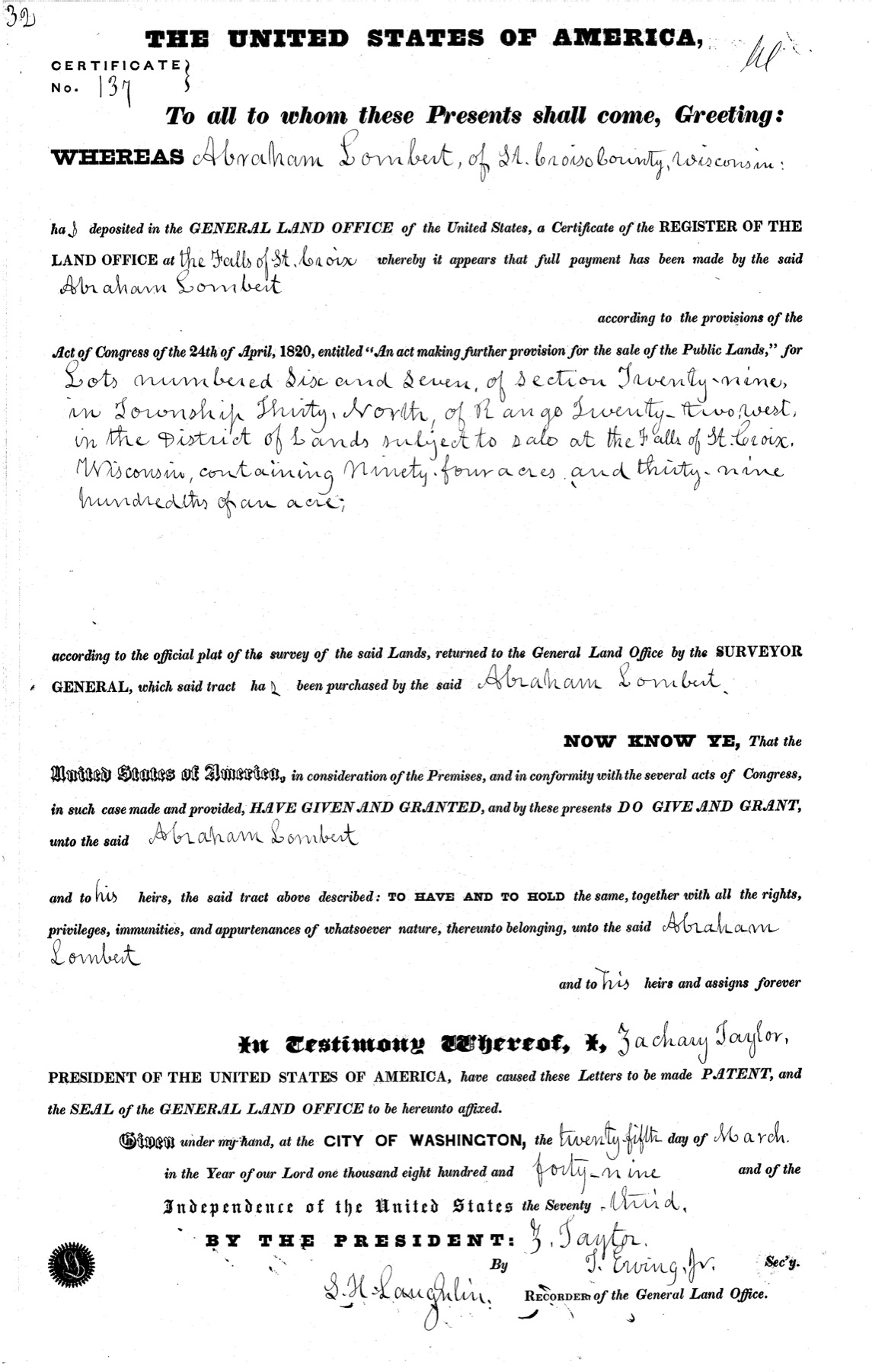
The 1849 land patent, certificate No. 137, to Abraham Lombert for lots 6 and 7 of section 29, township 30 north, range 22 west

The clerk spelled him "Abraham Lombert, of St. Croix County, Wisconsin": Minnesota Territory was only three weeks old. The patent, in the name of President Zachary Taylor, grants the island to him "and to his heirs and assigns forever."1 Click the page to see it large.

The patent's two lots are exactly the island. The surveyor wrote their acres on the plat, and they add up to the patent's figure to the hundredth of an acre.2

Lot 658.69 Lot 735.70 The patent94.39 acres

Abraham bought the whole island.

IV. Little Canada

Home was the farm: about ninety acres on the west shore of Lake Gervais.1 Abraham became one of the little settlement's steady hands. In 1850 the county named him an election judge for Little Canada. He was appointed to run its new post office, remembered later as the first in Minnesota outside St. Paul,4 and in 1851 he helped oversee the building of the road to White Bear.12

Until then the French Canadians' church was Father Galtier's log chapel in St. Paul. When Little Canada founded its own parish, St. John the Evangelist, in October 1851, Abraham gave twenty acres for its cemetery, and the logs for the first church came from his land, "the large logs hauled by sleighs over the snow."11

A county history calls him "the stubborn Abraham Lambert." When the new church began charging pew rent in 1852,

Abraham Lambert objected to paying it but, not wanting to miss Mass, he built himself a folding chair and every Sunday carried it to church, set it up, then carried it home again.

Wall, Ramsey County History, 1964, from a Lambert family manuscript

In 1853 his son Louis bought the eighty acres just south of the farm.1 The family's names spread along the west side of the lake, and the county history of 1881 found three sons still farming Abraham's claim.10

The island did not stay in the family long. By 1867 the county map lettered the water Lambert's Lake, and put another man's name, P. Jervais, on the island.19 When it was sold, and why, is in the county deed books, which have not yet been read.

V. The Lake Goes Dry

When Abraham bought the island, the water around it was mostly three to six feet deep, eight to eleven in the east pocket: a lake you could pole a boat across and touch bottom almost anywhere. It was the last few feet of water on a basin that had been filling with peat for 9,000 years, and the island was a hill the glaciers left behind, with oaks on top.15
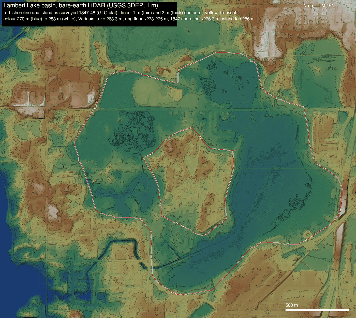
LiDAR hillshade of the Lambert Lake basin: the ring-shaped hollow and the island hill at its center

The basin today, from the state's elevation survey: the hollow of the ring and the hill of the island.

more

Nobody ever measured the depth. The surveyor's line along the shore in 1847 still sits at about 906 feet above sea level on both sides, and the floor of the basin today lies a few feet below it. The peat under the water runs ten to twenty-five feet deep in the wetlands along Lambert Creek.

The city drank it first. In 1870 the St. Paul Water Company ran a canal to Lambert Lake and counted it among the lakes "tributary to St. Paul." The lake sat about thirty feet above Vadnais, so a canal between them was a drain.14

Abraham died at Little Canada at the end of August 1875, at eighty-three, and was buried at St. John's, in the cemetery on the land he had given. Rose Angèle died the next August.18 He may have lived long enough to see the lake that carried his name begin to fall.

Eleven years after the canal, the county history wrote the lake's first obituary:

has since been drained into Vadnais lake, so much so that a large portion is now occupied as meadow lands.

Neill, History of Ramsey County, 1881

Then a farmer finished the job. In the winter of 1893–94 A. K. Barnum, who by then owned the island and nearly the whole shore, hired a man to dig more than a mile of ditch to Lake Vadnais, through springs and quicksand, "for the purpose of draining the former." The two ended up before the Minnesota Supreme Court over the bill.14

By 1899 the government's mapmakers found only marsh. They drew reeds where the ring had been, and one contour line around the island.20

In 1916 Ramsey County dug its own ditches through the old bed, and more in 1927. From the 1930s a developer sold house lots on the dry ground.14

In 1957 the Lake Vadnais area voted to become a village: Vadnais Heights.16

Then came the freeway. Interstate 35E was built past the old lake beginning in 1964.16

The ditch that drained the lake is Lambert Creek now, and in 2021 crews dug its bends back in. A pond sits in the old footprint, and a scrap of open water, less than an acre, is still listed by the county as Lambert Lake.14

Epilogue The Name Stays

The island left the family within twenty years, and the lake is nearly gone. The name stayed: on the maps, on the creek, on the pond. The county history of 1881 gave the credit to the son:

This lake was named in honor of Louis Lambert, who purchased a portion of the island located near its center in an early day.

Neill, 1881

The only purchase on record is his father's. Either way, it is the family's name.1, 10

And the family went on.

  1. Eustache Lambert about 1618–1673, from near Boulogne to Pointe-Lévy; m. Marie Laurence, 1656
  2. Gabriel Lambert, Sieur de Sainte-Marie 1657–1719; m. Françoise-Renée Roussel, 1683
  3. Louis-Joseph Lambert, Monsieur de Sainte-Marie 1695–1760; m. Geneviève Rouer de Villeray, 1722
  4. Louis-Joseph Lambert 1725–1817; m. Marie-Thérèse Frontigny
  5. Joseph (Louis-Joseph) Lambert born 1749; m. Judith Magnan, 1777
  6. Abraham Lambert 1792–1875, Lauzon to Little Canada; m. Rose Angèle Demers, 1822
  7. Louis Abraham Thomas Lambert 1825–1900
  8. David J. Lambert 1871–1928
  9. Joseph Eugene Lambert 1894–1968, Cloquet
  10. Marjorie Jane (Lambert) Delyea 1919–1998
  11. Mary Elizabeth Richey born 1950
more

The line follows the family tree, with the 1822 marriage and Abraham's parents from the Saint-Nicolas register and the early generations from Roy's history of the seigneury. More than one unrelated Lambert family lived in Lauzon, so the links from Eustache to Abraham still want checking against the original parish registers.5, 6, 17

From Lake Gervais the family went north, to the forests and mill towns of northern Minnesota.

        Part of Abraham's 1849 farm is a county park now, on Edgerton Street by Lake Gervais. The family calls it Abraham's Park. William and Alex pass it every day on the way to school.

        And Eric Richey, the twelfth generation from Eustache, lives at 3921 Woodview Ct in Vadnais Heights, about 0.84 miles from the island Abraham bought in 1849.

        Explore every map yourself. Below, every map of the lake from 1856 to 2026 sits on one frame: play it through, drag the year, or split the screen between two years.

        ↔

        Sources

        Every date, acreage and quotation above comes from one of these; the small numbers in the story point here. Where the record is thin or disagrees with itself, the note says so.

        Records

        1. Bureau of Land Management, General Land Office Records. Patent to "Abraham Lombert," lots 6 and 7, sec. 29, T30N R22W, 94.39 acres, Falls St. Croix certificate 137, 25 March 1849, accession MN2090__.032 (the image above). Patent to Abraham Lambert, lots 1 and 2, sec. 8, T29N R22W, 91.25 acres, certificate 59, same day, MN2090__.005. Patent to Louis A. Lambert, E½SW¼ sec. 8, T29N R22W, 80 acres, Stillwater, 20 June 1853, MN2090__.155. An exhaustive pull of all 1,569 patents in T28–30N, R21–23W found no other federal purchase by Abraham, and no other purchase at the lake before 1853.
        2. Government survey plat of T30N R22W (surveyed 1847–48; MnGeo georeferenced GLO plats, Minnesota Historical Society). Lot 6, "A. 58.69"; lot 7, "A. 35.70"; the island's total, 94.39; the ring and island together, "A. 357.15". Parcel outlines on the maps: BLM PLSS CadNSDI government lots.
        3. Lake Gervais and Little Canada parcels: the same BLM survey layer, lots as patented.
        4. Minnesota Pioneer, 10 April 1850, p. 3 (election judge); Minnesotian, 17 January 1852, p. 3 (paid as judge); Weekly Minnesotian, 1 August 1857, p. 4 (the Little Canada post office, "Abraham Lambert appointed"). Library of Congress, Chronicling America.

        Quebec

        1. J.-Edmond Roy, Histoire de la seigneurie de Lauzon, 5 vols. (Lévis, 1897–1904), archive.org. Vol. 1, ch. 19, pp. 255–261 (Eustache: the donné, his mark, the 1653 grant and the eels, the farm called Sainte-Marie), p. 165 (Jean Dumets, ancestor of the Demers, beside Eustache), p. 202 (the 1667 census: Gabriel, aged 20, running the farm), pp. 258, 262–263 (Gabriel's marriage and his plea of deafness); vol. 2, pp. 41–42 (Gabriel "de mœurs douces et tranquilles"; Louis-Joseph, Monsieur de Ste-Marie, the militia command and the first pew; his death on 21 January 1760), pp. 266–268 (the summer of 1759, "cinq longs mois" in the woods); vol. 3, p. 229 n. 2 (a Magnan–Lambert marriage, 1777); vol. 4, appendix (the 1776 commissioners at Pointe-Lévy and Captain Joseph Lambert); vol. 5, pp. 34–37 (November 1828: the cross planted "sur la terre d'Abraham Lambert" at Beaulieu, and the site moved in July 1829), pp. 349–359 (cholera, 1832; the hail at Saint-Jean-Chrysostome and the third year of famine, 1834). Page numbers come from the OCR's page markers and may be off by one. Roy notes that more than one unrelated Lambert family lived in the seigneury.
        2. Saint-Nicolas parish register transcriptions, François Marchi, genealogie.quebec (stemma4web): the marriage of Abraham Lambert, "fils de Judith Magnan et Joseph Lambert," and Rose Angèle Demers, "fille de Rosalie Foucher et Michel Demers," 22 January 1822 (Saint-Nicolas, 1822, p. 2, act M2; records 381992, 381995); the baptism of Rosalie Lambert, born 10 May and baptized 11 May 1823, godparents Judith Magnan and Michel Demers (382453); the household of Michel Demers and Rosalie Foucher, including Rose Angèle and Modeste, and Michel Demers's death on 29 July 1838 (75672, 75673); Abraham as witness at the Demers weddings of 1829 and 1832 (139056). A secondary transcription; the original register images have not been seen. The family tree's earlier date and place for the marriage are corrected here from this register, which MesAieux also gives.
        3. Usher, "Demers, Modeste," Dictionary of Canadian Biography, vol. 10 (biographi.ca): son of Michel Demers and Rosalie Foucher; missionary to the Oregon Country with F.-N. Blanchet from 1838. Also Lemieux, "Provencher, Joseph-Norbert," DCB vol. 8, for the bishop who recruited him.
        4. Association de la Propagation de la Foi, Notice sur les missions du diocèse de Québec, No. 1 (Quebec: Fréchette, January 1839), pp. 22–23 (the Columbia mission; "un trajet d'environ deux mille lieues à travers le continent"); Rapport sur les missions du diocèse de Québec, No. 2 (January 1840), pp. 22–27 (Cowlitz: "très-propre à recevoir des colons ; le climat est doux, le sol fertile"; the Willamette chapel of 70 feet by 30 and its first Mass, 6 January 1839); No. 3 (January 1841), with the year's contributions listed parish by parish. archive.org. The English renderings in the story are this page's own.
        5. J. Monet, "Lambert, Eustache," Dictionary of Canadian Biography, vol. 1: born about 1618 "probably near Boulogne"; a donné; at Sainte-Marie among the Hurons in 1646; land at Pointe-Lévy in 1653 and the house Sainte-Marie, "in memory of his youth in the Huron country"; married Marie Laurence 1656; died at Quebec, July 1673. Henry Gosselin, Eustache Lambert: Donné Extraordinaire (2001), for the 1644 arrival.

        Minnesota histories

        1. Edward D. Neill, History of Ramsey County and the City of St. Paul (1881), p. 281 (the lake "named in honor of Louis Lambert"; "has since been drained into Vadnais lake") and p. 289 (the family's route, 1841–45; the Oregon plan; "where he died in 1875"; three sons still on the claim).
        2. Margaret Whitney Wall, "Little Canada—Heritage from the French," Ramsey County History 1:2 (Fall 1964), pp. 10–12: the Ducharme marriage at St. Boniface, the return south, the cemetery gift, the church logs, the pew rent and the folding chair, and "the stubborn Abraham Lambert," drawing on George Belland's manuscript "The Abraham Lambert Family" and Msgr. Arthur Durand's 1957 monograph. The gravestone puts the cemetery gift in 1853 and the family's arrival at St. Boniface in 1841; the story follows Wall and Neill.
        3. Alan R. Woolworth, "White Bear Lake," Ramsey County History (Fall 1965), p. 5 (the 1851 Little Canada–White Bear road).
        4. Warren Upham, Minnesota Geographic Names (1920), p. 442, repeating Neill on the name.
        5. The draining: Neill (1881), p. 434 (the St. Paul Water Company's 1870 canal; the lakes "tributary to St. Paul") and p. 281; Swank v. Barnum, 63 Minn. 447 (1896), Minnesota Supreme Court (David Swank's 5,963-foot ditch of 1893–94, "for the purpose of draining the former, and thereby improving the defendant's farm"); Vadnais Lake Area Water Management Organization watershed plan, Appendix B (County Ditches 13 and 14, 1916; laterals 1927), and its Lambert Creek and Lambert Lake Pond pages (the 2005 pond, the 2021 meander); Minnesota Historical Society, Davidson Company papers (Stockdale Farms plats, about 1933–1948); Ramsey County GIS and the Minnesota DNR Public Waters Inventory, 62-30 (the 0.68-acre Lambert Lake today).
        6. The lake's depth and ground: the 1847–48 meander line read over Minnesota LiDAR elevation data; USGS Water-Resources Investigations Report 94-4062 (peat); SSURGO soils; Minnesota Geological Survey, Ramsey County geologic atlas C-07, plate 3 (the island's till). Worked in research_notes/lake/lake.md.
        7. Area history on the maps: White Bear Township history pages (from Catherine Carey, White Bear: A History, 2008); Press Publications Vadnais Heights history columns (the 1957 vote, 277 to 83; I‑35E); Gem Lake history (gemlakemn.org); U.S. census populations.

        Family

        1. The family tree on Ancestry: the line from Eustache Lambert to Abraham, and Abraham → Louis Abraham Thomas Lambert (1825–1900) → David J. Lambert → Joseph E. Lambert (1894–1968) → Marjorie Jane Delyea (1919–1998) → Mary Elizabeth Richey (1950); the children and their years. The tree's generations two to five are not yet checked against the parish registers; where Roy or the Saint-Nicolas register gives a different date or name (Gabriel's marriage in 1683; Abraham's father as Joseph Lambert), the story follows them.
        2. Find a Grave, St. John the Evangelist Cemetery, Little Canada: Abraham Lambert (memorial 50657843; born 5 June 1792, Lauzon; died 30 or 31 August 1875, age 83); Marie Esther Augé (72497788; Rose Angèle's dates, 1797–1876; Esther born 1835 at Saint-Jean-Chrysostome); Rose Angélique Ducharme (201643373); Joseph Modeste Lambert (71154227, born January 1838).

        Maps

        1. L. G. Bennett, Map of Ramsey County (1867); G. M. Hopkins, Atlas of the Environs of St. Paul (1886), plate 19; P. M. Dahl, Plat Book of Ramsey County (1898); Atlas of Ramsey County, St. Paul Real Estate Board (1931): University of Minnesota Libraries, UMedia. 1859 township plat: Minnesota Historical Society. Andreas atlas (1874): David Rumsey Map Collection.
        2. USGS, White Bear 1:62,500 topographic quadrangle (surveyed 1899, published 1902).
        3. Air photos: Ramsey County GIS (1940–2024); University of Minnesota Borchert Map Library, MHAPO (1947 USGS, 1957 Ramsey County). 2026: Google Maps imagery, stitched from 18 screenshots.
        4. Live map layers: Ramsey County orthophoto services; MnGeo GLO plats; Esri World Imagery, World Street Map, World Physical Map and Light Gray Canvas (with HERE, Garmin and OpenStreetMap data).

        The journey

        1. The stops and years are Neill (1881), p. 289, Wall (1964), p. 10, and the gravestone. The lines between them are reconstructions; data/journey.geojson marks each leg documented, reconstructed or assumed, and the map draws documented legs solid, reconstructed legs dashed, and the alternative 1845 route dotted. The dates and day counts are a working scenario in data/itinerary.json (its basis in data/journey.md): leaving Lévis about 10 May 1841, St. Louis about 5 June, the winter there, Fort Snelling about early May 1842, a long wait at Mendota for a northbound cart party, St. Boniface about 5 September 1842, leaving about 29 May 1845 and reaching Lake Gervais about 6 July 1845. Every date is estimated and shown as "about." If the family left after the harvest instead of in spring, the St. Louis stay was about five months, not ten. The gravestone says they reached St. Boniface in 1841; Neill's winter at St. Louis puts them there in 1842, and the map follows Neill.
        2. G. M. Davison, The Traveller's Guide through the Middle and Northern States and the Provinces of Canada (Saratoga Springs, 1840 ed.); Theodore Dwight, The Northern Traveller (New York, 1841): the St. Lawrence chain of steamers and stages, the Lewiston–Buffalo railroad, and the Chicago–Peru stages.
        3. J. B. Mansfield, History of the Great Lakes, vol. 1 (Chicago, 1899), quoting the 1841 lake-trade report; Wilford Woodruff, journal, 19–28 September 1841 (Buffalo to Chicago on the Chesapeake, seven days).
        4. William J. Petersen, Steamboating on the Upper Mississippi (Iowa City, 1937), pp. 143–44, 235–36.
        5. "Sinclair, James," Dictionary of Canadian Biography, vol. 8; Lawrence J. Barkwell, "Sinclair Expedition to the Oregon Territory," Louis Riel Institute (2007).
        6. Demian and Jeffrey A. Hess, "Minnesota Red River Trails, 1835–1871," National Register of Historic Places Multiple Property Documentation Form (Minnesota SHPO, 1989), section E; NRHP nominations 90002201 and 90002202, Red River Trail (Woods Trail), 1990; Rhoda R. Gilman, Carolyn Gilman and Deborah M. Stultz, The Red River Trails (1979); John C. Schultz, "The Old Crow Wing Trail" (1894).
        7. J. Fletcher Williams, A History of the City of Saint Paul, and of the County of Ramsey (St. Paul, 1876), pp. 304–05 (448 miles by Otter Tail and Sauk Rapids; caravans out early in June, in early July; about 15 miles a day).
        8. Route geometry: the lines follow OpenStreetMap waterways and rail corridors and Natural Earth river centerlines, with the cart roads traced from the 1850s–70s GLO survey plats; gaps between them are hand-routed by terrain. The Woods Trail as drawn measures about 468 miles, against Williams's 448. Route lines: © OpenStreetMap contributors (ODbL). Historical base maps: David H. Burr, Map of the United States of North America (London: J. Arrowsmith, 1839), and J. N. Nicollet, Hydrographical Basin of the Upper Mississippi River (1843), both Library of Congress, warped to the web map, so they fit approximately; underneath, Esri's World Physical Map. Travel icons drawn for this page.

        Generations and descendants

        The timelines of the generations from Eustache to Abraham, and from Louis to Eric, with their sources as the research gives them. Dates marked "general reference; not re-checked" are background history, not family records.

        Pictures

        Period pictures of the kinds of boats, carts and places the family would have seen. None shows the Lamberts themselves; each caption says how close it is.

        1. No illustrations loaded yet.

        Still to find

        Made by Eric Richey. Millwright Software, October 2026. Back to the top.